Ever since my first childhood visit to a railway museum, I have been interested in the railways of the UK. As I boy, I especially loved steam trains, and the smell and sound that accompanied them. Now, my passion for the railways has shifted to a more historical basis. I love the romantic mystique of steam trains stopping off at quaint village platforms or beach side stations. Whilst railways originally criss-crossed the country, today’s network is a fraction of that size. The 20th century saw a massive cull of railways deemed difficult or expensive to maintain. Many areas were cut off entirely from the railway network as a result of the closures. Today, these closed lines can still be seen, albeit with their remains buried under modern infrastructure, or laying forgotten.
In this series, I explore what remains of the abandoned railways of the UK by foot. Travelling by foot allows me to get up close to the remains of lines, stations and infrastructure. I also dive into the histories of these lines, why they closed, and whether they should reopen.
The Horsham and Guildford Direct Railway stretched out across the South Downs of Surrey and West Sussex. Closed by the Beeching cuts of the 1960s, it now forms part of the Downs Link, a footpath and bridleway. At 16 miles long, this line connected Guildford with Christ’s Hospital and Horsham. On an overcast October day, I explored the northern half of this line, between Guildford and Cranleigh.
A Brief History of the Line
Formation

The Horsham and Guildford Direct Railway was proposed to Parliament in 1860. By this time Guildford was already a busy junction station, with trains heading to Woking, Godalming, Farnham, Reigate and Reading. It was run by the London and South Western Railway (LSWR), one of the largest companies in southern England. One of their biggest rivals was the London, Brighton and South Coast Railway (LBSCR). The two rival companies did not want their lines to be connected, as the H & G would do. Predictably, building of the line was delayed for several years as negotiations took place. Eventually, the independent line was acquired by the LBSCR, who already owned the line between Horsham and Christ’s Hospital.
Construction finally began in 1862, but progress on the 16 mile route was slow. Three years later, in 1865, the line was ready for inspection. Somewhat suitably for a line used to delays, there were further setbacks. The existing timetable for Guildford stations was cause for concern, as the new trains would have to fit within that. Additionally, the newly built Rudgwick station was built on a fairly steep gradient, posing safety concerns. The line was finally opened in full in November 1865, a full five years after being proposed. Though slow for the time, it probably would feel like an exceptionally speedy build for today’s society!

At first, the line was single tracked between Peasmarsh Junction, where trains would leave the Portsmouth line, and Christ’s Hospital. A passing loop was installed at Baynards station, which would enable trains running in opposite directions to pass. Passing loops were later installed at Bramley & Wonersh and Cranleigh stations. The 1930s saw much of the area’s railways electrified, including those owned by the LBSCR and LSWR. However, the line between Guildford and Christ’s Hospital was never modernised. The outbreak of the Second World War saw non-essential costs diverted from the railways. But, I propose a second reason for the electrification of the line being deemed a low priority.
Despite the line connecting two large towns and their more major railway lines, the service pattern was terrible. A 1950 article in the Railway Magazine by H.A. Vallance reported only eight trains on weekdays. That’s four in each direction, lower than the vast majority of lines today. Sundays were even worse, with a reported two services in total. There were a few more additional services in summer to the south coast, but that’s it. The line was poorly served and, to no-one’s surprise, passenger numbers were also very low.

Closure
Due to the poor passenger numbers, the line was reportedly losing thousands of pounds each year. It did manage to continue running after the Second World War, but not much longer. The death knell came in 1963 with a landmark report by the Chairman of British Railways, Dr Richard Beeching. His report, The Reshaping of British Railways, recommended the closure of stations and lines to save on costs. Railway historians dub the subsequent closure of railways as the Beeching Axe. Just over 4,000 miles of routes in Great Britain were closed in the 1960s, including the H & G. The last passenger service ran on Saturday 12 June 1965. Unlike many other lines deemed important to freight, all traffic ceased on the line. A group was formed just after the line’s closure, to reinstate the services, to no avail.
The track was lifted not long after closure. Many of the sites of the line, including Cranleigh station, were quickly bought for redevelopment. Much of the section north of Baynards Tunnel was purchased by Surrey County Council and Hambledon Rural District Council. The latter made the excellent proposal to turn the old track bed into a public footpath. In 1973, their proposal succeeded, and it signed a lease on the old route. In 1984, a 30 mile long path and bridleway, known as the Downs Link, was formally opened. This connected the North Downs Way near Guildford to the South Downs Way near Shoreham-by-Sea. This new path would utilise two closed railway routes, the Steyning Line, and the H & G (or Cranleigh Line).

Exploring the Line
Part 1 – Guildford to Bramley & Wonersh
My walk began on the banks on the River Wey, just outside of the medieval town of Guildford. The Cranleigh Line split from the Portsmouth Direct Line at Peasmarsh Junction, south of Guildford station. A quick bit of research online showed me that the junction was near the busy A3100. Additionally, there were remains of an old railway bridge which the Cranleigh Line crossed the River Wey over. The riverbank would make for a much more pleasant start to my walk than next to a noisy road.
I completely overlooked one element in my master plan: the weather. It had been raining in recent days, which had turned the footpath into a slippery mudslide. Cursing myself for not bringing better footwear, I admitted defeat. Researching the area after my walk did little to help. I saw that there was a footpath from Peasmarsh Junction which would go over the Wey on the old bridge! On the plus side, I did walk through a nice park and then the pleasant village of Shalford. Pleasant to look at, if not to listen to, as a never-ending line of cars and lorries whizzed past.
Shuddering at the thought of how much one of the cute houses would set me back, I passed Shalford station. This was on the line between Guildford and Redhill, essentially connecting Reading with Gatwick Airport. It runs almost parallel to the Cranleigh Line, serving Dorking and several smaller towns and villages. It is interesting to me how one line succeeded whilst the other line did not.

I passed Shalford’s village green, on which was an interesting sign. Designed in 1922, it depicts Saint Christopher carrying the Christ Child through a shallow ford. I hoped this aquatic sign was not an omen, as I looked nervously to the darkening sky. After being blasted by lorry turbulence for several minutes, I was relieved to see the entrance to the Downs Link. My railway walk had begun.
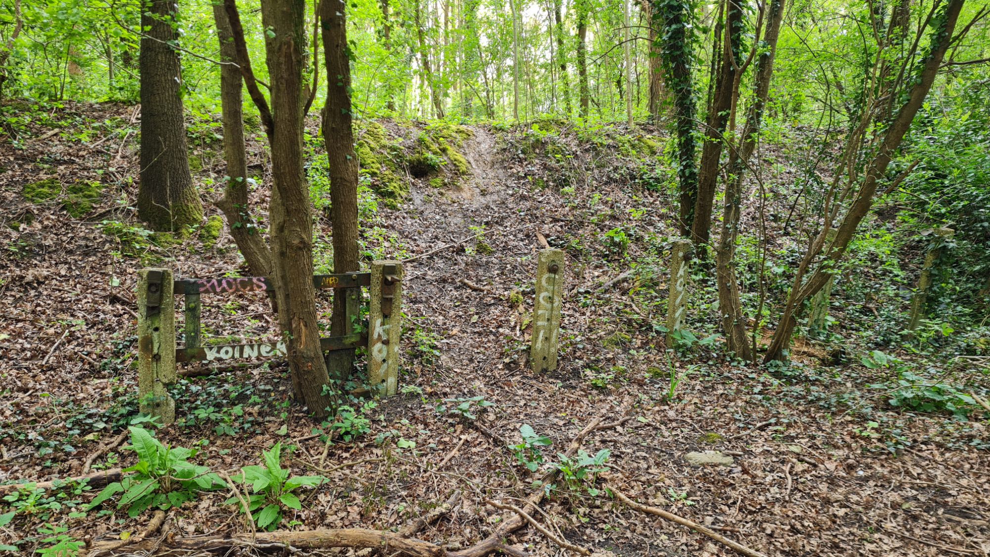
Immediately, there was evidence that a railway line once ran through here. The railway would have had to manage the undulant nature of the South Downs without very steep inclines. As a result, the line used a mixture of cuttings (a V-shaped trench dug into the earth) and embankments. I also noted the numerous road bridges over the line, each of which the perfect medium between sturdy and decorative. It wasn’t just the hilly terrain that the railway had to navigate. A footbridge took me over the Cranleigh Waters, a tributary of the River Wey. To my right, I saw where the old line crossed the water on a bridge. Now, only the abutments stood, partially covered by greenery.
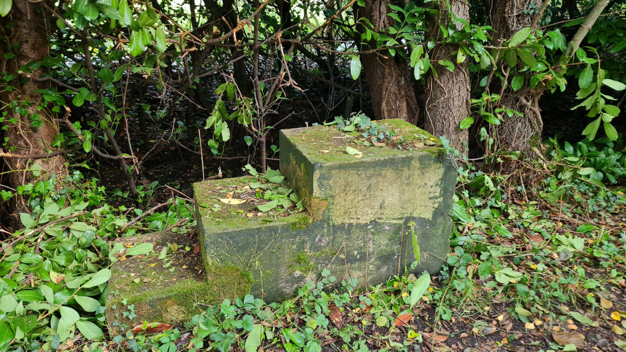
Two more discoveries stood out to me on this section. One was a set of three stone steps to one side of the path. I wondered what the purpose of these were, and whether they were a piece of old railway infrastructure. The second discovery wasn’t related to the railway at all. Along a wooden gangway was a viewing platform across to the meadows. For the first time on this walk, I felt completely at peace. I honestly could have stayed there for longer, but I had to press on.
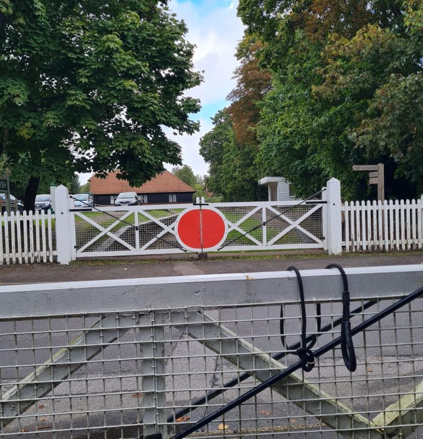
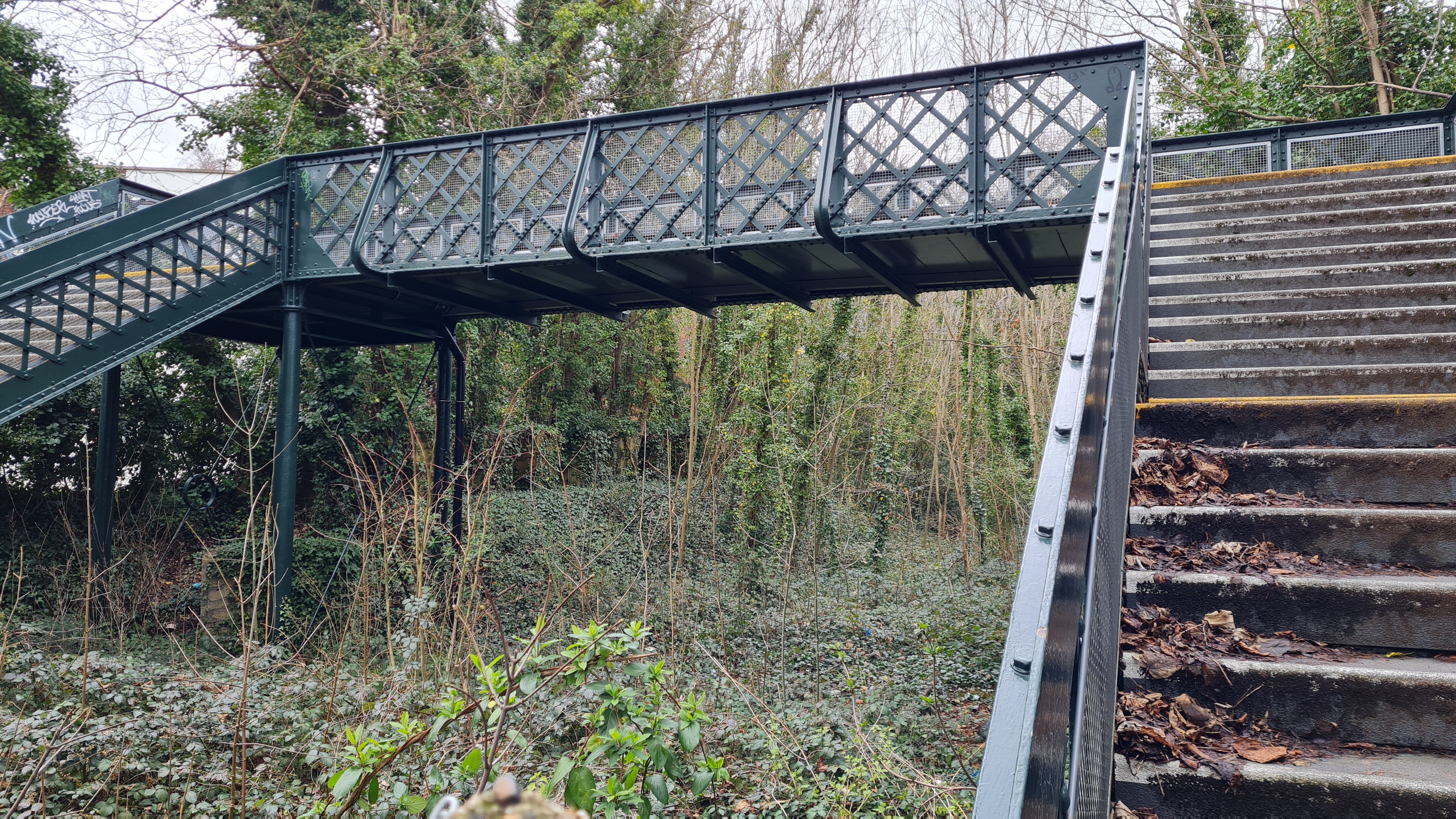
As I ran parallel to the waterway for a few more minutes, the rears of houses started to appear. I was back among civilisation, specifically the village of Bramley. Looking ahead, I could see the path open up and a long platform appear to my left. I had reached Bramley & Wonersh station, and what a find it was.
Bramley & Wonersh
Year Opened: 1865
Year Closed: 1965

History of the Station
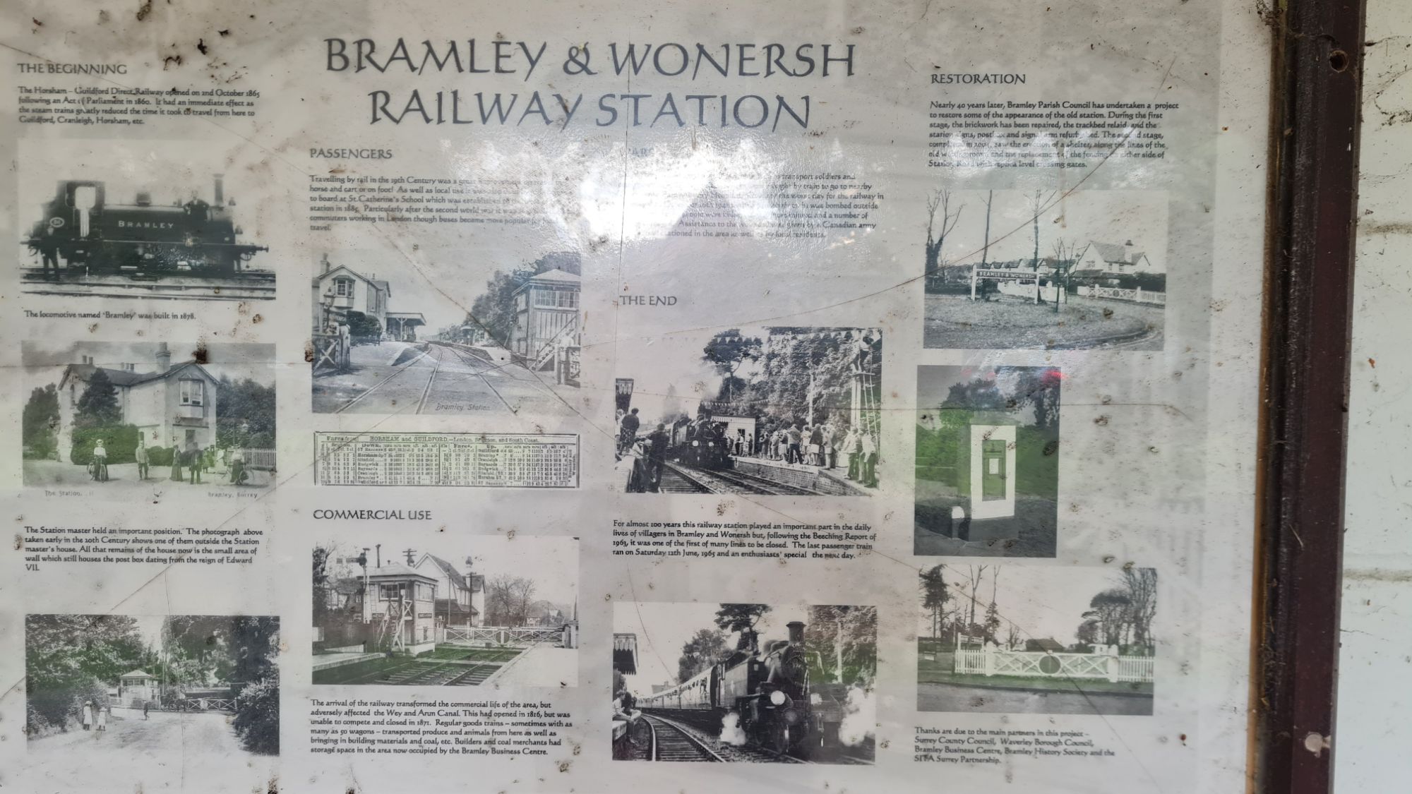
The station, originally known as just Bramley, was opened in 1865 with the rest of the line. It was originally a single platform station, but doubled in size when the passing loop was installed. Geographically, it is within the village of Bramley, but very close to the village of Wonersh also. To recognise this, the station was renamed as ‘Bramley & Wonersh’ in 1888.
Bramley & Wonersh also has the misfortune of being host to the darkest moment in the line’s history. In December 1942, a German Luftwaffe bomber machine gunned a train approaching the station. It also dropped a bomb, which hit a nearby embankment. Eight people lost their lives that day, including the train’s driver and guard. A plaque commemorating this stands in the shelter on the southbound platform.

In 2002, the restoration of Bramley & Wonersh station was proposed by the local council. As well as clearing the overgrown path, replica station signs and level crossing gates would be built. A waiting room would also be added, to the specification of one from the old station. In 2005, the restored project was officially opened.
The Station Today
By this time, I had walked several abandoned lines and had seen some great remains. These pale into comparison with Bramley & Wonersh, the most complete station remains to date. I chuckled with glee as I walked up the southbound concrete platform and to the waiting shelter. The station signs were looking resplendent in green and white. The level crossing gates were just how I pictured. I even discovered what I believe is an original gradient marker in the undergrowth. The only thing missing from the fantasy was a station building. A business centre stands there now, though I think it would benefit from a railway-themed cafe – I’d go there!

Walking into the shelter, I was again surprised by what awaited me on its wall. My favourite thing had to be the 1890s extract from Bradshaw’s Timetable. It listed every train that ran in both directions between Christ’s Hospital and Guildford. It also listed how much a journey would have cost the Victorian passengers. Next to it, there was an informative board listing the history of the station, complete with old pictures. The commemorative plaque to the victims of the 1942 attack also hung here. Finally, there was an old metal sign from the Southern Railway, warning trespassers of fines. I think I was safe from any fines when visiting the station that day!
Standing on the station platform, I found myself transported to a bygone age. I could imagine being a passenger, waiting impatiently for the Guildford train to come chugging into view. It may have been the beautifully restored features, or the quaint village surroundings itself. Whatever it was, I found myself spending several minutes at the station, admiring each element. Clearly, the residents are very proud of this station. It is an excellent example of a community showcasing the legacy of a long-closed station. I only wish there were more restored stations like this one.
Part 2 – Bramley & Wonersh to Cranleigh
After leaving Bramley & Wonersh, trains would have run for 5 miles until the next stop on the line. I squeezed past the reconstructed level crossing gates, and felt a drop on my shoulder. The sky finally followed through on its threatening colour, and the heavens opened. Thankfully, I had packed a coat, and was entering a section with heavy tree cover. Not so thankfully, the weather kept changing its mind on whether to rain or not. I must have put my coat on three times. The rain also made the path slippery with mud. The conditions did not dissuade me from pressing on, nor did a fairly steep incline. The slope on my left to the valley below quickly got steeper and steeper. I was surprised – surely this would have been a massive exertion for trains heading towards Cranleigh? My thoughts were interrupted by an unexpected obstacle. A tree was laying across the path!

A tree across a railway line would mean a day of cancellations, delay and misery. A tree over this disused line was easy to navigate with my very limited athletic ability. Based on my performance here, I would be quite good at the limbo. As I pondered this, the last of the rain ceased, and I could finally take my coat off. Continuing to climb, the last few traces of settlements faded away. Aside from one or two farms which backed onto the old line, and the road bridges, it was very green. It was also slightly isolating, and nearly an hour must have passed until I came across another soul. Perhaps they lacked my limbo expertise to traverse the two trees. I say two trees, as the second of these soon lay at my feet. I am used to not being around people when walking, but this was definitely another level. I felt both tranquillity and unease at seemingly being the only person on this stretch.

Towards the end of this stretch, information boards started to appear. These described the history of The Wey & Arun Canal and current restoration progress. The canal followed a very similar path to the Cranleigh Line, but predated it by several decades. In its heyday, the canal was 23 miles in length and would have carried freight traffic from Surrey to Sussex. The much faster steam train would have decimated its work and it was abandoned in 1871. Since 1970, the Canal Trust have been redeveloping and reopening parts of the canal. Their ultimate aim is to open the canal in full. I have traversed parts of the Grand Union Canal by foot, and find a peacefulness by canals. Based on what I have seen of the area, I think it would be very appealing to boaters. I missed it on this occasion, but the Gosden aqueduct near Bramley looks well worth a visit. More information on this canal and its restoration can be found at https://weyarun.org.uk.

Part 3 – Cranleigh to Guildford (via Bus!)
For the last couple of miles of this walk, my energy battery had been completely spent. This gave me an even bigger respect for the Victorian railways. They connected communities and transported passengers in relatively rapid time, decades before the motor car. Alas, I did not have a steam train zipping me along, so I decided to end this walk in Cranleigh. On approach to the station, I found another hint to the past in the ‘Railway Cottages’. If I had the money, I would happily live in a old railway cottage or station building.
Cranleigh was quite pleasant to walk through. I particularly liked the market square feel of Stockland Square, now a Sainsbury’s, and the large greens near the road. The village is also well served by buses to Guildford, so made for the ideal finishing point of this leg. Thankfully for my motivation, Cranleigh was also very close to halfway between Guildford and Christ’s Hospital. Before leaving for Guildford, I had one more site to examine, the remains of Cranleigh railway station.
Cranleigh
Year Opened: 1865
Year Closed: 1965
History of the Station
Cranleigh station was opened in 1865 as one of the first on the Horsham and Guildford direct railway. Like Bramley & Wonersh station further up the line, a passing loop and second platform was built in 1880. According to old pictures, the station was on a fairly noticeable curve. There was also a small yard and coal depot to accommodate the movement of local goods. Maybe it was due to its location and how busy Cranleigh felt, but I expected the station to be larger. Some great old pictures of the station in its heyday can be found at http://cranleighrailway.info.
When the line was closed in 1965, Cranleigh station was one of the first sites to be redeveloped. Permission was granted for the Stocklund Square shopping centre and its car park to be built. Though a downgrade in my eyes, at least the station found a second use. Subsequent research also revealed that the old station footbridge was re-erected at Liss on the Portsmouth Direct Line.
The Station Today
Unlike Bramley & Wonersh, the Downs Link footpath runs adjacent to the site of the old station. Turning off from the path, I walked into a car park, hardly a great conclusion to this walk. The platforms and tracks were decimated by the car park and loading bay of Stocklund Square. The station front was replaced with a row of shops, which later became a Sainsbury’s supermarket. The latter row of shops has some nice brick work, and there is a cute clock in the square. But, it is ultimately another example of a station which was decimated in full.
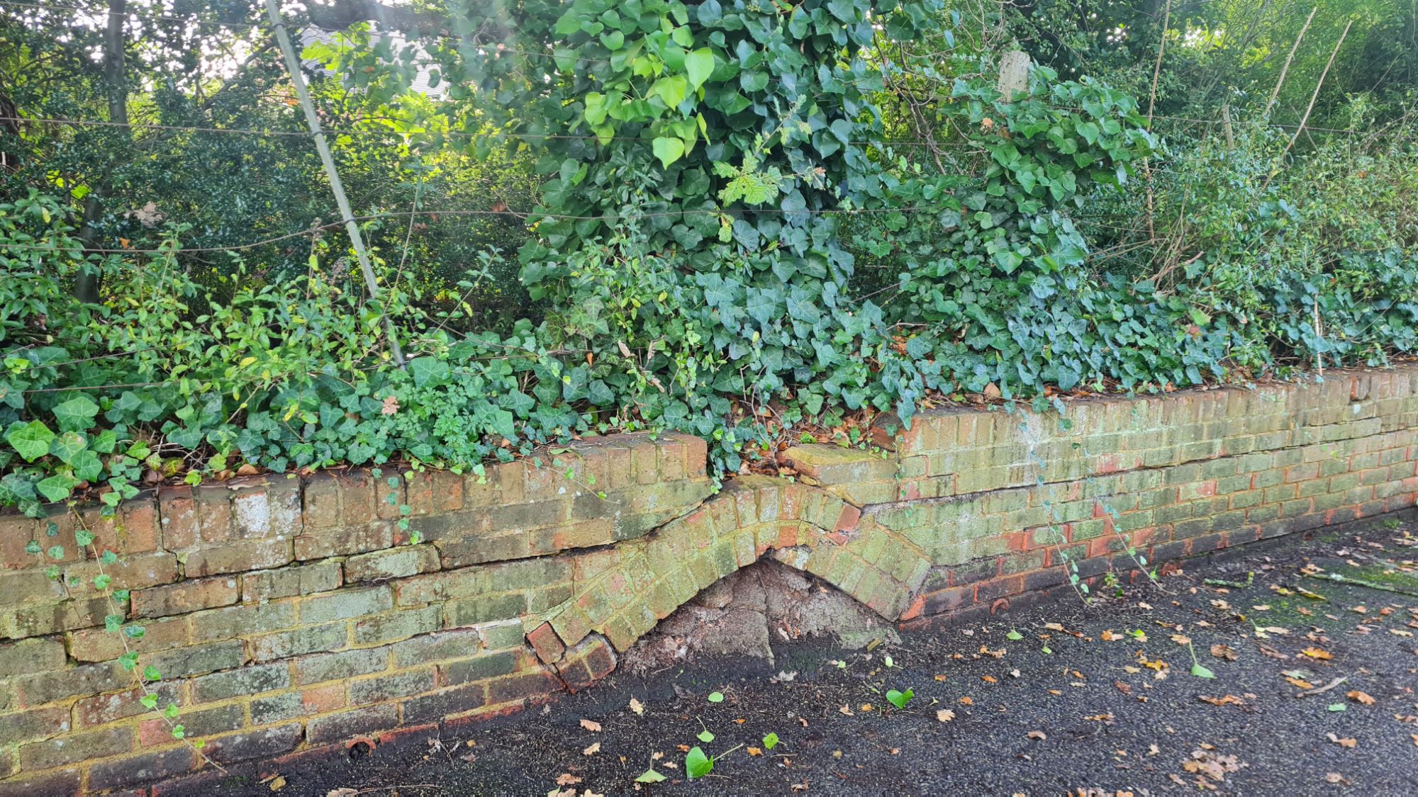
The only potential trace of Cranleigh station is a couple of low brick walls. One acted as a barrier between the car park and the overgrown shrubbery, and had a nice arch pattern. The other bisected the car park length ways, and looked part of the Stocklund Square development. The former may be a remnant of the old platforms of Cranleigh. Except, based on pictures I know that the platforms were curved. Therefore, I do not believe that there are any surviving remains of Cranleigh station.
While waiting for the bus into Guildford, I got chatting to a local resident, who lives in Bramley. Though they did not grow up near the line, they were within touching distance to the old station for years. We talked about efforts to reinstate the line between Guildford and Cranleigh at least. Though nothing had ever progressed, they were optimistic for the line’s future.

In the months following the walk, I did some research online on these plans. I discovered that the track bed for the section between Peasmarsh Junction and Cranleigh has been protected. This means that there have been at least considerations from the council to re-open the line. In 2009, a report by the Association of Train Operating Companies listed stations and lines to be re-opened. Per the report, the opening of Cranleigh would also reduce pressure at Guildford station. A BBC article, which includes a link to the report itself, can be found here.
Conclusion
I believe the decision to close the line was justified. This line is almost perfectly in the middle of the lines between Guildford and Haslemere, and Dorking and Horsham. The small towns and the villages that were served by the line were surely cut adrift by its closure. But I think that’s the difference between this line, and the lines around it; the settlements were fairly small. On this section of the line, whilst I saw plenty of road bridges, I only passed through two settlements. For most of this walk, I felt like I was the only person in a one mile radius. This was definitely the most rural line I have done in this series to date. It was also clear to see why passenger numbers were so low when the line was open.
There is an interesting question on the cost vs benefit of reopening the line as far as Cranleigh. These settlements are surely larger than they were in the 1960s, and therefore passenger numbers would be higher. Reopening the line would also help to take more cars off the road. One of my reservations is whether a two station branch from Guildford would sufficiently serve the community. Another is a concern stretching way back to 1860 when the line was proposed; does Guildford station have space? The 2009 report did state that the cycleway and the heritage around Bramley & Wonersh would need to be protected. I wholeheartedly agree with this statement. I like how much of the line has been repurposed, whilst paying homage to its railway past. Sites such as the restored Bramley & Wonersh station are testaments to the community. If the line was to reopen in the future, I hope it doesn’t forget about its past.

Thank you for taking the time to read this post on my old railway walk between Guildford and Cranleigh. If you enjoyed reading, please do leave a like.
If you would like to be notified when future posts are published, please feel free to subscribe.
For any locals, would you like this line to be reinstated?
Do you have any recommendations of abandoned railway lines that are well worth exploring?
Please feel free to leave a comment below, or send an email to editor@thebloggingdj.com.
In the next Walking Abandoned Railways, I head north of London for the first time. In the West Midlands, on the outskirts of Birmingham, lies a branch line with some surprises in store.
Walking Abandoned Railways – The Series So Far:

#3 – The Palace Gates Line – Seven Sisters to Palace Gates (Wood Green) – London, UK

#4 – The Edgware, Highgate and London Railway – Mill Hill East to Edgware
– London, UK
#5 – Parkland Walk – Finsbury Park to Alexandra Palace – London, UK

#6 – The Tooting, Merton & Wimbledon Railway – Wimbledon to Tooting Junction – London, UK

Thank you for your excellent and informative article on the Guildford to Cranleigh railway, now part of the Downs Link Way. I cycled this pathway with my daughters several years ago. Restoring the line to Cranleigh would make a lot of sense in terms of the increased population there and traffic reduction.
LikeLiked by 1 person