For the past couple of weeks I have been reading Peter Caton’s Essex Coast Walk, in which the author traverses across the entire Essex coastline. I found the book very informative and enjoyable to read (you can read my review of the book here) and it inspired me to continue one of my walks.
Last year I started the Thames Estuary Path, which would take the walker from Tilbury all the way to Shoeburyness in Southend. I got as far as Pitsea before having to stop. The months passed and, for a variety of reasons (mostly the weather and work), I had been unable to continue this public footpath. Yesterday I felt inspired from reading about Peter Caton’s travels so I took a train to Pitsea and resumed the Thames Estuary Path.
My first challenge was actually finding where the path resumed. Out of Pitsea train station there is a sign directing walkers but it wasn’t completely clear where it wanted you to go. I wasted 20 minutes walking in a circle in an admittedly nice part of Pitsea before realising that the sign was facing a narrow bush lined track between the railway station fence and the pavement.
After a couple of minutes the bushes ended and I was in open countryside. There was a clear path running next to the railway line that looked slightly picturesque in the presence of open hilly grassland. However, from the first step, I became aware that the ground was absolutely sodden and that taking soft steps around the worst of the mud and water was the key. At this point I was probably walking more side to side than I was forwards.

The path became yet more difficult when several horses separated me from the edge of the field. Not wanting to disturb their grazing, I tried to make a semi circle around them but the condition of the ground meant I was moving further and further away from the gate at the bottom. Several times I got lost and got my clothes and skin pierced with prickly sticks. I felt like I was in that scene in The Lord of the Rings when Frodo and Sam are trying to navigate a stone maze; there didn’t seem to be a way out. Eventually, with my socks sodden and mud splattered down my jeans and trainers (I wasn’t prepared for those conditions) I made it out.
The second field was much easier to get through despite being very muddy. It was very peaceful, until a train came roaring past metres away. Finally I got through the worst of the mud and found myself on a country road opposite the quaint St. Margaret’s Church. The church seemed very remote and its location was very soothing, until a boy racer zoomed by doing his best Colin McRae impression in a beefed up car. I knew he would turn around so I waited by the edge of the road. Sure enough, he did. I then hurried to where the path left the road and went on to a footpath that took me on to Bowers Marsh.

It would have been nice to explore this nature reserve more but the day was already slipping away (I started the walk in the early afternoon). Following a dirt road I was then led under the A130 to Canvey Island, reminding me how close I’d been all this time to the noise and bustle of civilisation and I tried to make good time through this section so I wouldn’t be annoyed by the cars any longer.
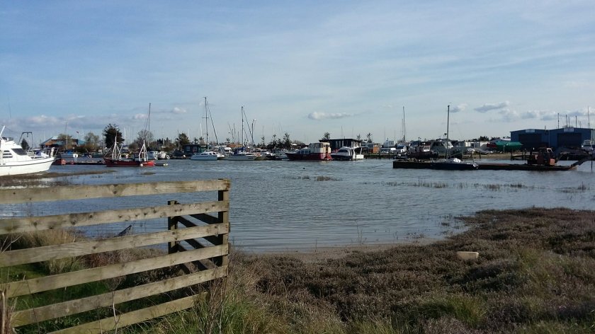
Once I was away from Bowers Marsh I entered Benfleet near the train station, on the attractive river front. I passed many boats on this section, some were brightly renovated and obviously used regularly. Others were faded and rotted on the mud banks; honestly I find these kind of boats more interesting to look at. It was just entering the evening peak, with the first of the commuters from London arriving. Knowing that I only had a couple of hours until sunset, I quickened my pace for the four mile stretch to Leigh-on-Sea.

This part of the Thames Estuary Path took walkers along a wide embankment that ran parallel to both the railway line and to Canvey Island, albeit both separated from me by water. With the wind starting to pick up and the scenery looking more wild, this was the most exposed I’d felt on the entire path.
I had the opportunity to cross the railway line and enter the park containing Hadleigh Castle but I wasn’t sure how long it’d take me to get through so I stayed on this part. I now wish that I had taken thar opportunity, for the pretty river front scenes at Benfleet were now long behind me and the scenery was bleaker and, I’m sad to say, monotonous. There was nothing of real interest near me, with the sights on the other side of the railway line. Occasionally eerily happy music crossed the water from Canvey and I had the mental image of someone being given a balloon from a drain.
The last part ran parallel to Two Tree Island and though the occasional rotted boat could be seen, the one note surroundings continued right up to Leigh-on-Sea. The walk had taken me 4 hours to complete, including getting lost in the fields, but finally, mud stained, I was waiting for my train back home.

I had high hopes for the second part of this walk, knowing that I was edging closer to where the Thames meets the sea. However, bar a couple of gems in the rural church and the water front at Benfleet, there wasn’t a great deal of variety or sites of interest. I’d also recommend to any walkers wanting to do this to wait until the warmer and drier months, as the paths were quite cut up and sodden in places. Knowing the final part of the Thames Estuary Path, from Leigh to Shoeburyness, well, I knew that it is going to be the highlight of this public footpath.

I’m glad you decided to carry on towards the sea.
I did the Pitsea to Benfleet section again last winter – I’m rechecking routes ready for the second reprintingof 50 Walks on the Essex Coast. And I too found it muddy. It’s been fine every time I’ve walked it in summer though.
The route from Benfleet to Leigh via Hadleigh Castle is probably the more interesting – and the Salvation Army tea shop near the castle worth a visit. I describe both in 50 Walks on the Essex Coast. It makes a good circular walk, maybe with lunch in Leigh, or one way by either route retuning by train.
LikeLiked by 1 person