
Since I was young, I have always been interested in the railways. Trips to railway museums fuelled the mystique of eras long before my birth, when steam trains chugged up and down the country, stopping at quaint villages and seaside towns, the majority of which now lay abandoned and overgrown. I have recently begun to explore the abandoned railways in my home city of London, investigating remains that have been lost to time, looking into what caused the lines to close, and judging whether it would be beneficial for the lines to be reopened in the future.
On an overcast but dry weekday in March, I followed the line that branched off at Seven Sisters station and headed through to Wood Green, the Palace Gates line.
A Brief History of the Line
The Palace Gates line was opened in 1878 by the Great Eastern Railway, though plans to run a branch line up to Alexandra Palace were in place from 1866, when “The People’s Palace” was under construction. Initially, the line would have ascended the very steep grounds up to the venue, though this was scrapped in the planning stage due to the high costs involved; the line would instead terminate at the bottom of the hill, leaving visitors to the palace facing a 20 minute walk uphill from the station. In contrast, the Great Northern Railway managed to build a line from Finsbury Park which did reach the summit; this was later closed but can still be walked along as part of the Parkland Walk.
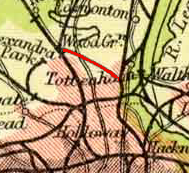
Passenger usage was never high on the line, as Alexandra Palace never seemed to attract the numbers that its southern counterpart, Crystal Palace, did, and also the fact that there were two stations closer to the palace than the terminus of the Palace Gates line. The line continued until the early 1960s, at which point it had less than ten trains in each direction, only at peak hours. The line was closed in 1963, with freight traffic lasting only one year longer, with the tracks lifted in 1966.
Exploring the Line
Part 1 – Bridges, Endless Bridges (Seven Sisters – West Green)
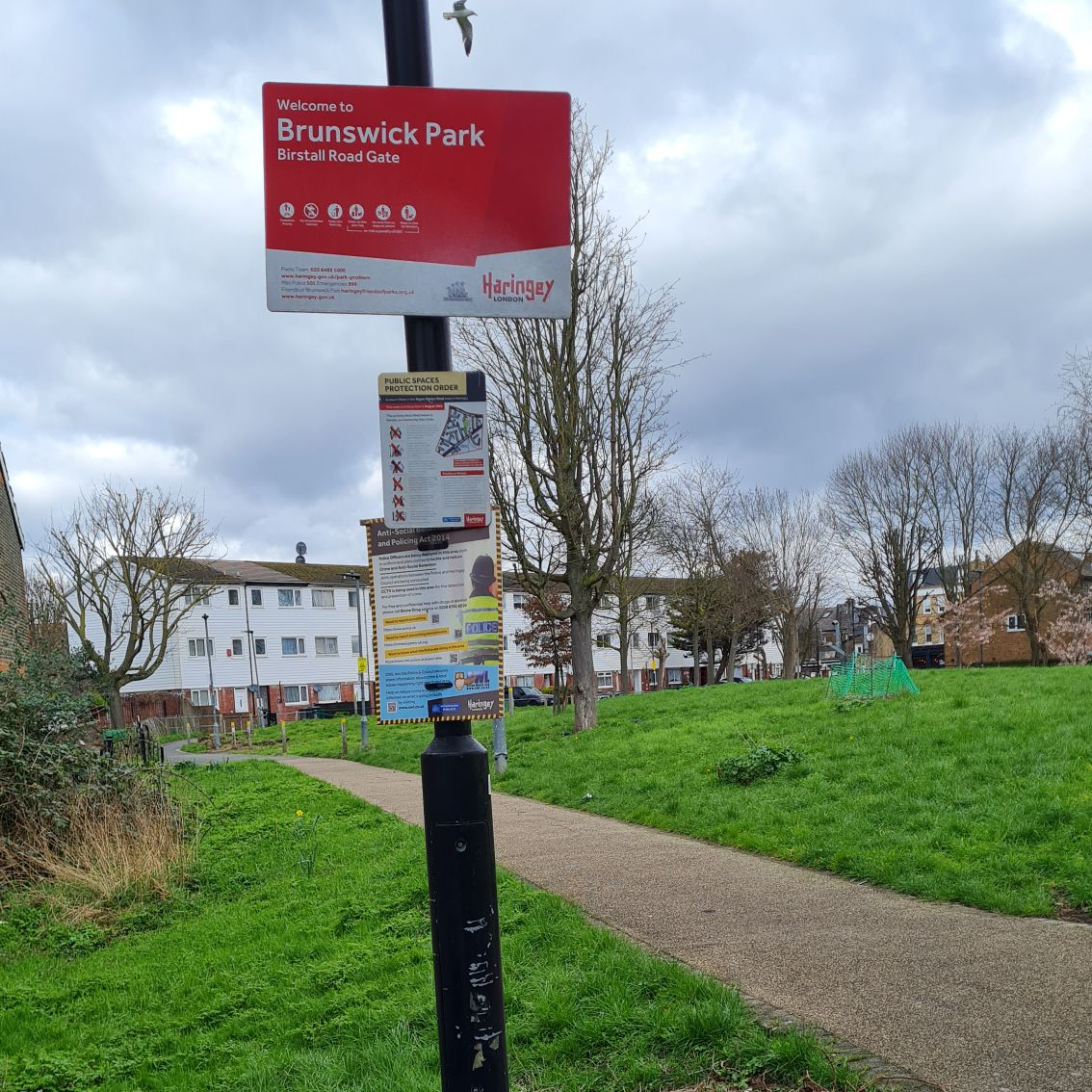
The branch began at Seven Sisters station in North London, which today has handy connections with both the London Underground and London Overground, but used to be a much larger National Rail station. The embankment to the left of the station, which carried the platforms and branch to Palace Gates, was flattened shortly after the line was closed and replaced by Brunswick Park, which today hosts an extensive collection of outdoor gym equipment that two people were using on the day.

My first task was to relocate the line upon leaving Seven Sisters. The line was originally built in a cutting, which was refilled when the tracks were lifted, and now has been replaced with housing and private allotments. After taking a wrong turn twice, I stumbled upon the rather aptly named Brunel Walk, which definitely could not be a coincidence. The path was blocked by some private allotments, of which there was so public access, so I walked down the parallel Seaford Road and onto Avenue Road. This brought me to the first of the most common remains of this line, a bridge.
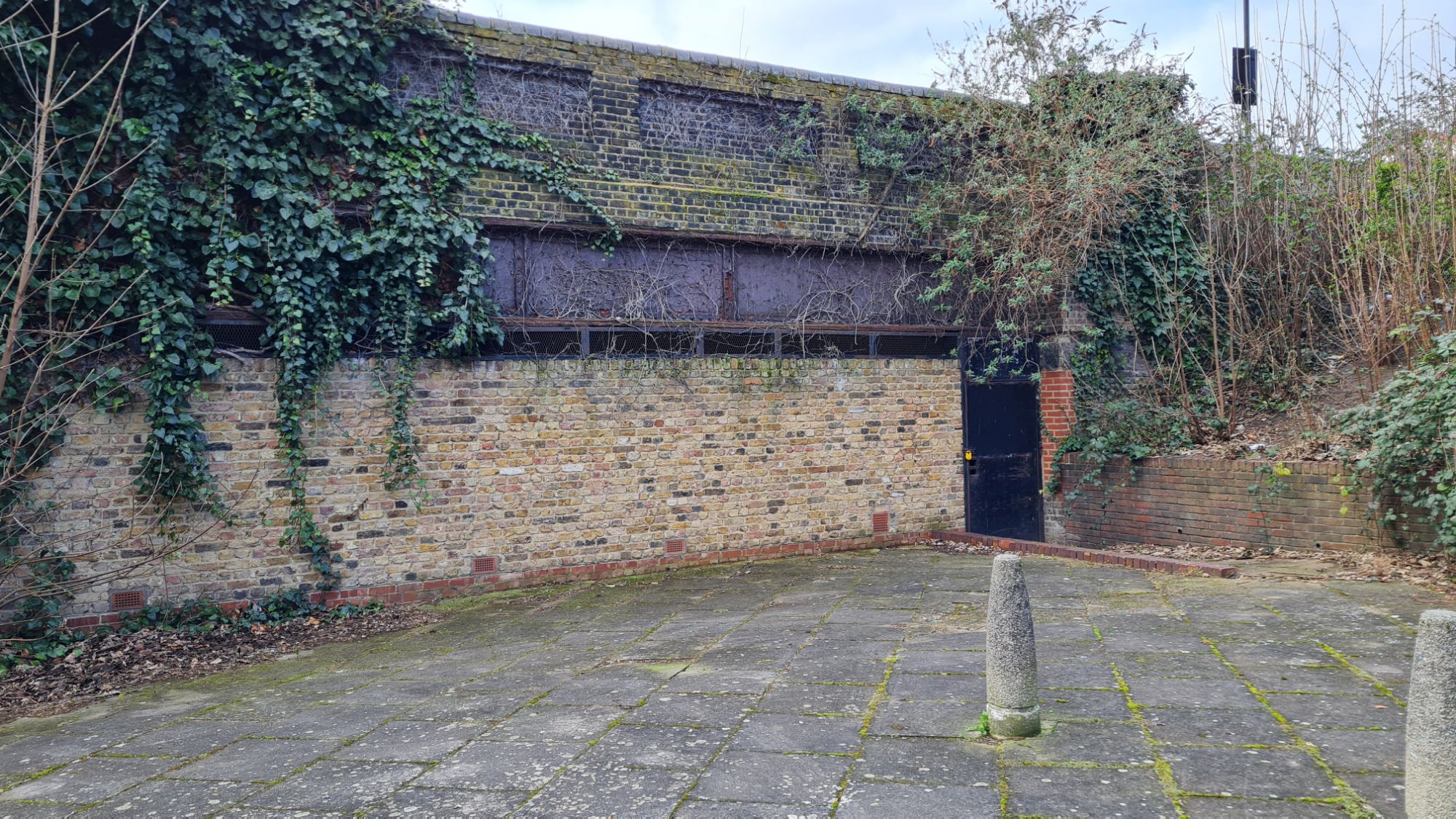
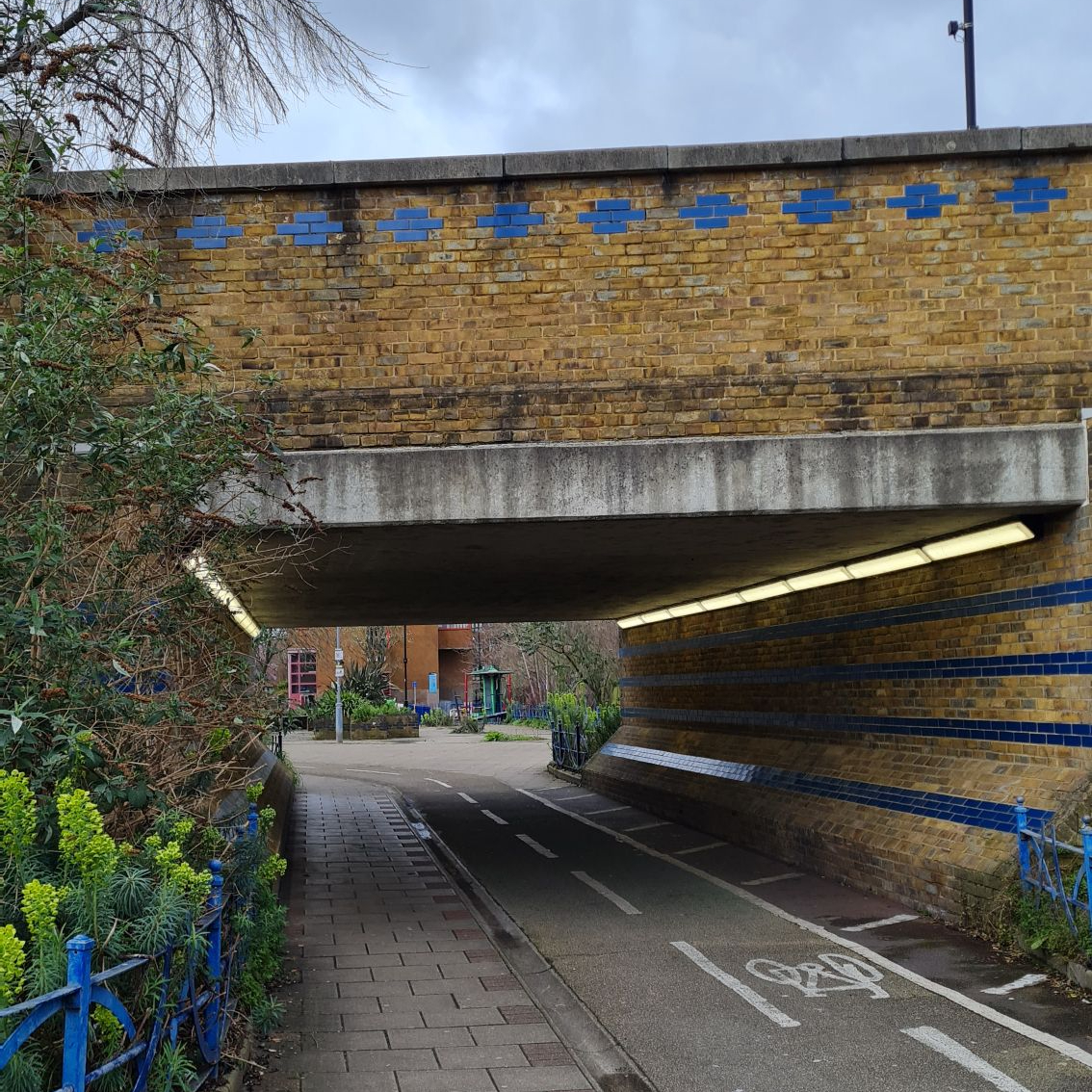
The South Tottenham area was already heavily built upon, and bridges had to be built to take the cutting containing the line beneath existing roads. To the right was the previously aforementioned allotments and, walking down some steps to the left and on to a patch of green I got up close to the mouth of the bridge, the brickwork of which has survived remarkably well despite 60 years of non-use. A boarded up but equally impressive bridge could be seen just two minutes away down Sturrock Close, at which point I wondered whether locals knew that they were living on the path of an old railway line, and what they must think of a man in walking gear and a backpack walking to the end of their cul-de-sac, taking a picture of a wall, and walking back the way they came.
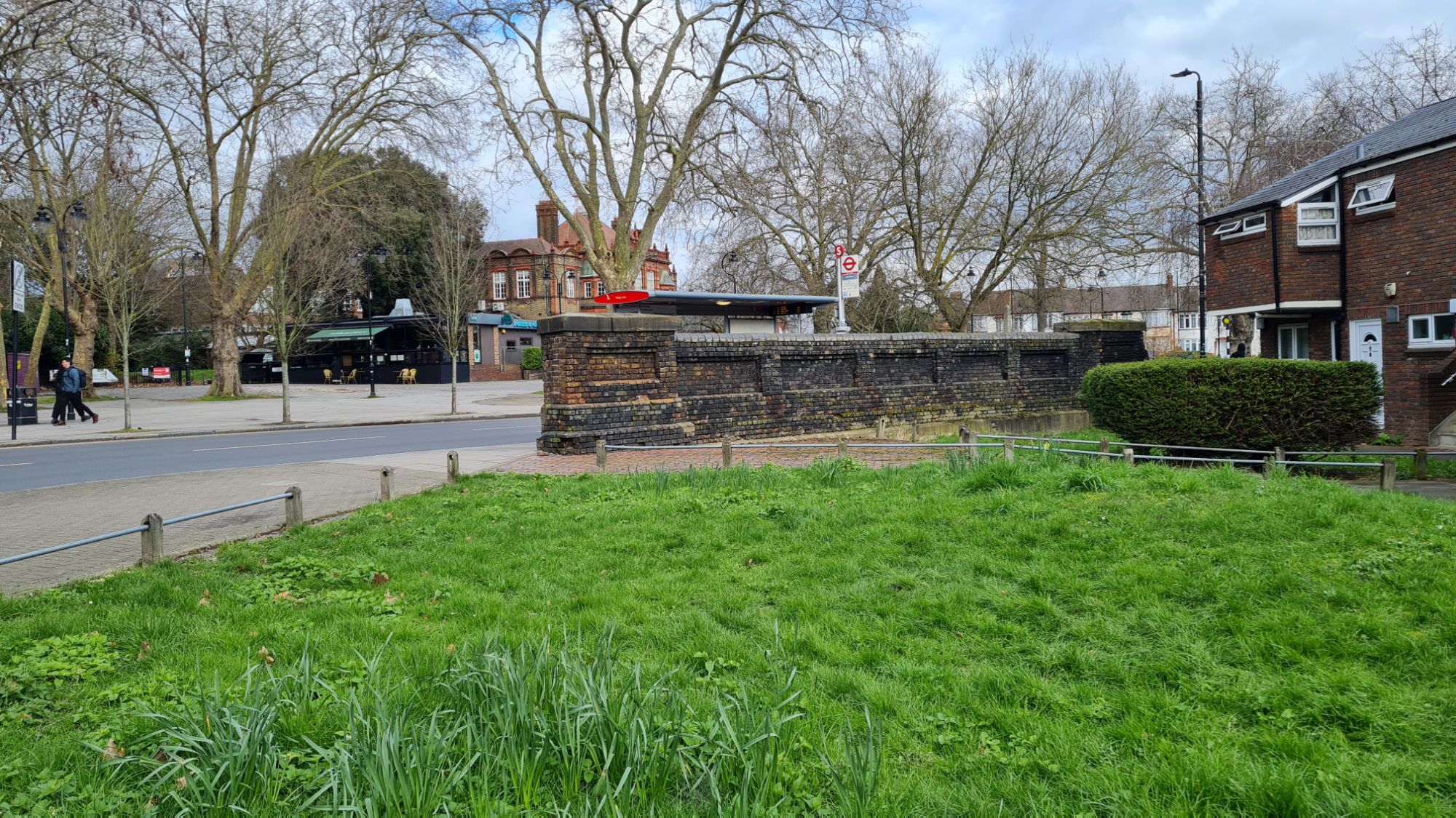
It was then that I approached the first intermediate station on the branch line, West Green, of which very little of the actual station remains. When the cutting was infilled, part of the station frontage stayed in place for many years after, eventually being demolished in 2003. The site of the station is now a school, however there are two remnants of West Green to this day. The first is wall behind a bus stop on West Green Road, which was clearly the abutment of a bridge that the railway would have run coming into, or leaving West Green station. The second set of remains can be seen on Belmont Road, a twin arched railway bridge that backs on to the rear of the school grounds. For a better view that you can get up close to, the end of Ivatt Way opens up into a patch of green and the other side of the twin arches. As it was a weekday and therefore a lot of people around Ivatt Way and the nearby school, I moved on to the next section of the line.
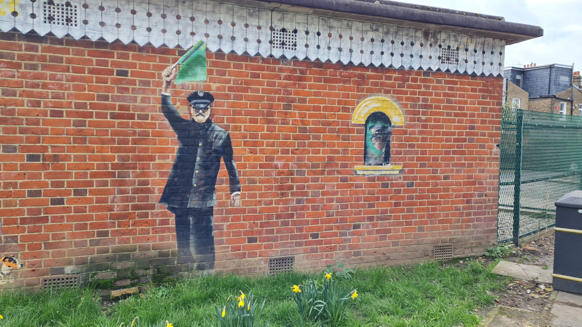
A pathway between the nearby Langham Place and Downhills Park Road features the next gem of the walk. Haringey Council has placed replica railway lines into the concrete where the trains would have run. A plaque on the ground between the two sets of tracks recognises the Palace Gates Line. My favourite part of this however is a mural on a small building of a steam-era guard waving a green flag, a lovely touch. The way was once again blocked by some private allotments, this time the Mannock Road allotments. Thankfully, Mannock Road ran parallel to this latest obstacle, so I quickly got to the other end and to the next bridge on the route.

This is now a pedestrian and cycle way under Westbury Avenue, also known as the A1080. Though the cutting appears to have been infilled, the footprint of the line can clearly be seen in the complex of flats known as The Sandlings. The railway had several sidings at this point, possibly for freight or carriages, hence the expanded footprint. Once again nothing remained of the old railway infrastructure, so I quickly passed through and towards the heart of the Wood Green area.
Part 2 – Shoppers, Endless Shoppers (Noel Park and Wood Green)
It was at that point that the railway turned from being in a cutting to being on an embankment and, in typical fashion for this line, very little trace of the line can be seen today. This was particularly disappointing at the site of the second intermediate station of the line, Noel Park and Wood Green, temporarily the terminus before the extension to Palace Gates (Wood Green) was completed later in 1878. In the 1970s, the imposing Wood Green Shopping Centre was built, which destroyed all traces of the line, which would have crossed the road on a high bridge.
In contrast to my previous abandoned railway walks, I could not escape the sound of traffic and the mass of people going about their shopping, and I yearned for a park or a section not taken up by houses and roads. The slanted shape of a building containing a restaurant is the only hint that a railway bridge was once there, as it would have crossed the road slightly diagonally to the north-west, passing over what is now Station Road, into the grounds of another school, and out of reach for the next 10-15 minutes. Following the main road from the shopping centre, pushing through the constant stream of people, led me to the final nail in the coffin for the line, Wood Green on the Piccadilly Underground line. This, along with the nearby Turnpike Lane stop, ensured commuters could effectively get a very regular service into central London without needing to change trains.

At this point I would like to mention a brilliant YouTube video that was a great help for me in my research of the old line. The video is on the channel ‘Alan Snowdon Archive’ and is a narrated video of a steam train journey in 1960 between the old North Woolwich station (now also abandoned) and Palace Gates, via Seven Sisters. I have included a link to the video here (skip to around 6:00 for the Palace Gates branch). Watching the video, you get a real sense of how much the railway network in and around London has changed so much in the past 65 years; the extensive network of sidings for freight traffic from the docks and industrial hubs have, save for a few larger examples, completely vanished, steam traffic has been replaced by a mixture of electrification and diesel, and the boom in the motor car has meant that people in the suburbs of London did not need to rely on public transport to get around and out of the city.
Part 3 – Palace Gates (Wood Green) (Not Near the Palace Gates)

By now, I was approaching the terminus of the line, but before that, I passed the retaining abutments for a bridge over Park Avenue. Going up a set of steps next to the bridge took me up to the old embankment. Finally, I could hear the sound of birdsong rather than road traffic and people, an oasis in the desert of grey and beige which was this walk. The housing complex directly ahead of me has typically been built on the site Palace Gates (Wood Green), the end point of this branch. In a nice touch, some of this complex has been named ‘Palace Gates’ to reflect the area’s former life. A dead-end just off Dorset Road is my best guess of where the entrance to the station was, a tiny patch of grassy wasteland behind a couple of cars, with two ancient wooden benches and a brick wall. Behind this wall is the still existing Bounds Green depot, now where the Hitachi Azuma trains are maintained by LNER – there were even a couple of Azumas in the sidings when I visited. A connecting loop to Bowes Park station followed the depot, though this was only ever used by freight trains whilst the Palace Gates line was in existence.

There was one last thing to see on this route, a small brick hut which must have had some relation to either Palace Gates (Wood Green) station or the old sidings. I then turned out of Bridge Road and directly in front of me was the still existing Alexandra Palace station on the East Coast Main Line. Seeing this reinforced my view of how pointless this line was, save for a couple of intermediate stations built in areas where there was originally little connectivity to the railway network. Though it was named Palace Gates, this is further from the Palace itself than both the ECML station (originally called Wood Green), which had links to King’s Cross and towns and cities heading north, and also the station literally at the base of the Palace.

Conclusion
When I consider the purpose of this line, even when built it was an alternative route into London rather than a necessity for a suburban community. It allowed commuters to travel into Liverpool Street station and into the financial heart of London, but in a very convoluted way. The connectivity and the frequency of services on the London Underground simply sped up the line’s closure. Even when considering its purpose of reaching Alexandra Palace, it was again an alternative route rather than the best choice, as though those who built the line never truly invested in its function.
The walk along this route was similarly frustrating, having very little remnants of old railway infrastructure, aside from bridge arches under roads which have yet to be filled in. I constantly felt as though I was going down dead end roads to catch a glimpse of something worth documenting, and could not escape the sound of road traffic, in stark contrast to my walks along the Crystal Palace (High Level) branch and the Woodside and South Croydon Joint Railway.
The Palace Gates branch was never a necessity for the local communities, being a meandering way to travel to both London and Alexandra Palace, and therefore I do not believe it should reopen. In contrast to other abandoned branch lines explored, it probably has found better use as houses, schools and a shopping centre.
Thank you for taking the time to read my account of exploring the path of the Palace Gates line. If you enjoyed reading this piece, please do leave a like. At the time of publishing, I have since explored the route of another abandoned railway in London, this once extending from an existing Underground station – if you want to be notified when this post and other new posts are published, please do subscribe.
Have you ever explored the Palace Gates line, or do you have memories of when this line was active? Do you have any recommendations of abandoned transport hubs in London and further afield that are well worth exploring?
If any of these apply, please feel free to leave a comment below or send an email to editor@thebloggingdj.com – I read all comments left on my posts and try to reply to as many as I can, so would be great to hear your thoughts.
